In 1774 Governor Dunmore declared war against the indignious Americans. The war ended after Virginia's victory in the Battle of Point Pleasant on October 10, 1774.
John Carmack, Sr. was born about 1720 in Frederick County, Maryland. His father Cornelius Carmack.
Cornelius Carmack (1750),
John Carmack (1751),
William Camack (1761),
Nellie Carmack
Catherine Carmack Gray
(married Joseph Gray).
In 1774, John Carmack was wounded while serving in the Fincastle County Militia during Lord Dunmore's War.
John died in 1812 in Washington County, Virginia.
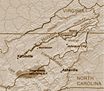
Fincastle County, Virginia was created in 1772 from Botetourt County and abolished in 1776. It was divided into Montgomery, Washington and Kentucky Counties.
Washington County, Virginia was formed from Fincastle County in 1777. It originally contained Sullivan County, Tennessee.
Frederick County, Maryland was created in 1748 from parts of Prince George's and Baltimore Counties. In 1776 it was divided into Washington, Montgomery and, Frederick Counties. In 1837 parts of Frederick and Baltimore Counties formed Carroll County.
Cornelius Carmack was born on June 18, 1736 in Frederick County, Maryland. He was the son of William Carmack and Jane McDaniel.
He married Margery Jane Evans on October 26, 1756 in Frederick County, Maryland.
Cornelius and Margery's children probably included:
Cornelius Carmack, Jr. (1759)
William Carmack (1761, married Mary Catherine Hartsock and Mary Yeary),
Joseph Carmack (1763, married Mary McMillan),
Jane Carmack (1765, married Thomas Henry),
Sarah Carmack (1767, married Hugh McGhee),
Jesse C Carmack (1769, married Ann Black),
Margery Carmack (1771, married John Grimes),
John Carmack (1773, married Mary Dougherty),
Elizabeth Carmack (1775, married James Henry), and
Susannah Carmack (1777, married Henry Livingston).
They settled in Washington County, Virginia 1773.
December 31, 1774 John Carmack had 470 acres surveyed on Sinking Creek.
January 12, 1775, Cornelius Carmack had 100 acres surveyed on Beaver Creek.
On January 31 1775, John Carmack had 97 acres surveyed on Sinking Creek.
On September, 2 1776, John Carmack was in charge of the road from Beaver Creak to Major Bledsoe's in Fincastle County, Virginia.
Cornelius, Sr. and Jr., William and John Carmack signed the 1777 petition of men living on the north Holston River complaining about the division of Fincastle County. They felt the line was not equitable and the court house was too far away.
William Carmack was a soldier in the American Revolution.
Cornelius, Sr. died July 18, 1824 in Livingston, Overton County, Tennessee.
Fincastle County, Virginia, was created in 1772 from Botetourt County. In 1776 it was divided into three counties; Montgomery, Washington, and Kentucky (which the state of Kentucky).
TheAmerican Revolutionary War(1775–1783) was between the Kingdom of Great Britain and the 13 colonies which became the newly formed United States.
There were two Beaver Creeks in early Washington County, Virginia. One (also called Shallow Creek) flowed through Bristol and emptied into the South Fork of the Holston River in Tennessee. The other was a south branch of the North Fork of the Holston River in current Smyth County.
American pioneers migrated west to settle areas not previously inhabited by European Americans.
Cornelius Carmac
225 ac
Treasury Warrant
on both sides of Cathrins fork, branch of Cove Creek, waters of the north fork of Holstein [Holsten] River
Beginning on the Hawfield Ridge above a path
at the foot of the knobs
October 19, 1782
Cornelius Carmack
130 ac
treasury Warrant
on the waters of Steels Creek
Beginning on the north side of the Big Ridge
corner to the land he now lives on
June 7, 1782
Cornelius Carmack
395 ac
Commissioners Certificate
on the head waters of Beaver Creek & Steels Creek
Beginning on the north side of the big ridge
corner to Richard Moors [Moore] land
corner to Moors & Nathaniel Gists land
at the foot of the big ridge
June 5, 1782
Cornelius Carmack
400 ac
on the waters of Beaver Creek
100 ac surveyed on January 12, 1774
includes improvements, actual settlement made in 1773
September 1, 1781
The Holston River flows from Kingsport to Knoxville.